The locks ranged from taking you 19 feet up to 16 feet down. The highest altitude we got to was 140 feet above sea level at lock 9. We had been warned ahead of time to purchase disposable gloves and extra bumpers due to the lock walls being wet and slimy, which they were. One of the locks (the first one) you placed your line behind a pipe in the wall of the lock and attached it to the centre cleat on the side of the boat. This way the line went up or down with the flow of the water. The rest of the locks we had to grab onto the ropes hanging over the edge of the lock. On the last two lock walls we encountered very tiny Zebra Muscles, an invasive species of muscle. We were both watching them as the waters fell and were surprised to see then squirt water at us. Gary took several photos trying to capture a squirt, but did not manage it.
Because Gary's drives into the locks (I am wary of docking) I am the grunt. It is my job to lean over the edge with the boat hook and grab a rope. Hence me wearing my life jacket just in case... Then, I have to help the boat slow to a standstill whilst Gary turns off the engine and grabs a rope at the back. At the end of the day I had biceps like Popeye!!!
Our first lock.
Entering the lock before the doors closed.
Yours truly holding onto rope (note how gloves match outfit!!!!).
Decisions, decisions - which way shall we go? Let's go to the Champlain Canal.
Crikey, we cannot manage to get to 10 mph let alone 45!!!!
A "dam" nice reflection of a dam.
We were delayed in one part of the canal by two geese families swimming across us. We slowed down and one family continued across our path whilst the other family hung behind quite agitated at being separated from its mates.
The maximum bridge height on the canal was 15 feet requiring some sailboats to be demasted if they wanted to take this route. Chicago also has low bridges if you decide to go through the centre of the city. We passed under one bridge that was even low for us (we are 14ft tall). Gary took a photo to show just how much clearance we had. We had to lower the antenna, as you can see or not see as we have lowered it!!!!
That night we encountered the first of many thunderstorms. New York is experiencing a heat wave and high humidity. In fact, it is warmer here than it is in Maryland which we left behind us to escape their hot, humid summers. C'est la vie!! I am practicing my French for when we enter Quebec!! The thunderstorm brought with it a rainbow, which was nice to see.
We motored by Fort Ticonderoga on Lake Champlain after completing all the locks. The fort was initially occupied by the French in 1755, taken over by the British in 1776 and finally captured by Ethan Allen (yes, the same one as the furniture store) and his Green Mountain Boys (Honey, let's Buy a Boat").
We spent the night at Vergennes, 7 miles up Otter Creek. The Creek was flooded on both sides due to the large amount of rain and thunderstorms the area had been having. It was raining but nice and warm so I sat outside with an umbrella listening to the birds and smelling the scented air. Gary though me crazy but still took a photo.
Vergennes was at the end of the creek with a 75ft waterfall to the right. It was quite full as you can imagine. What was nice, the town illuminated the falls at night and they were quite spectacular. We spent a nice evening having a meal in the town and listening to a local band concert in the town square. If it wasn't for the huge blood sucking mosquitoes it would have been a perfect night.
A nice pastoral scene.
Flooding on Otter Creek (more like a river than a creek).
I took a nice photo of an osprey leaving its nest (not the one above). The ospreys in New York are not as good at staying with their nests when a boat approaches as they were in Florida.
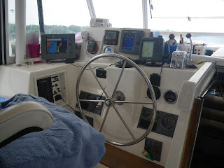
I have been asked questions about Gary's equipment (what a personal question!!!!). So, I took a photo of it (yes, ladies you can look!!) and will let him explain everything to you.
As we drove up Lake Champlain we looked at the depth gauge and it read 414ft - now that' s the deepest water we have ever been in so far. We are at 98 ft so the depth reaches over 300ft below sea level.
Kingston Rover Great Loop Map


Dad's equipment looks so large and complicated. How do you ever manage to get it to turn on... ok, that's enough of that. Can't wait to see the first Canadian posts.
ReplyDelete